

You must log in or register to comment.
Maybe Hari Seldon was Asimov’s rendition of Marx, stripped of any actual Marxism.
You think you just fell out of a coconut tree? You exist in the context of all in which you live and what came before you.
I personally call this stuff geographic determinism and I view it as a pseudoscience because a lot of it originated with the gun germs and steel book placing an overimportance on geography. Instead of scientific racism, its “hwite ppl are superior because cold winters forced them to develop complex society because otherwise they would freeze to death le natural selection”
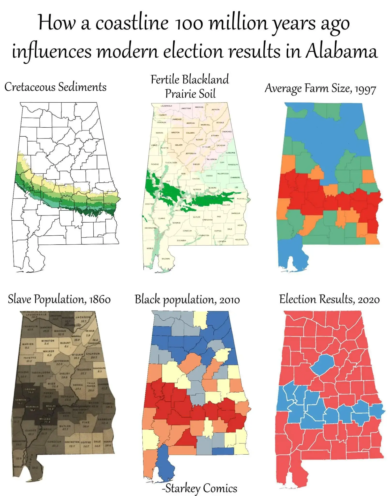
Im not saying that the south wasnt the region where slavery was the most prominent, but the south was in no way more disposed to slavery because hundreds of millions of years ago plate tectonics caused there to be a ridge formed in the south that just so happened to cause rivers to end abruptly, and people built mills there, and it’s more fertile, and oh uh a bunch of whites imported actual people as slaves because the land was just so good for slavery.
So what explains the graphic im malding about in the first place? Not geography. I dont got a fucking answer, I just know the answer isnt geography.
Yeah that whole theory of how Europe took control of the world always sounds so bogus to me. It’s bogus because up until Europe started taking slaves from Africa and America, they weren’t the most technologically or scientifically advanced or whatever. The middle east and India had already lapped Europe in terms of math, astronomy, medicine, etc.
The middle east in particular was so much more advanced that the Renaissance in part occurred because of Latin translations of Arabic texts from literally 400 years beforehand.
The arabic world was decimated by the Mongol invasions though, and the Islamic Golden Age was put to the sword. The reason they were reading 400 year old texts and not modern contemporary ones is because of this.
Honestly, the mountain ranges that held the mongols back from taking Europe and kept them relatively safe are a large part of the reason why Europe was able to catch back up.
By the way, it’s also a myth that Mongols were technologically backwards. They were at the very, very start before they took over chunks of China and incorporated their technology. The mongols were extremely adaptable, and by the end of their conquests they were using the most advanced siege weaponry on Earth.
a lot of it originated with the gun germs and steel book placing an overimportance on geography
I mean, there’s something undeniably influential about geography on certain cultural and economic trends. It isn’t a coincidence that England and Japan both became globe-spanning naval powers. And the impact of herd animals on the cultivation of disease is as undeniable today as it was a thousand years ago.
Im not saying that the south wasnt the region where slavery was the most prominent, but the south was in no way more disposed to slavery because hundreds of millions of years ago plate tectonics caused there to be a ridge formed in the south that just so happened to cause rivers to end abruptly, and people built mills there, and it’s more fertile, and oh uh a bunch of whites imported actual people as slaves because the land was just so good for slavery.
I think you’re reading a bit too much into the graph headlines. The plate tectonics creating a fertile region had a political consequence because it concentrated agricultural workers in a well-defined strip of land. Those agricultural workers had a socio-economic interest that was sharply distinct from the urban shipping centers along the coast and the ranch land to the north.
This doesn’t guarantee slavery. The Lakes of Minnesota and the California Valley were both fertile agricultural lands that failed to produce an active slave trade. But it does guarantee a concentration of particular industries. Not coincidentally, Minnesota and California have larger and more active labor movements concentrated in the areas where dense populations of agg workers live.
So what explains the graphic im malding about in the first place? Not geography.
Absolutely geography. That was the ahem bedrock of the split in regional concentrations of population, economic activities common to the region, and subsequent political formations within these regions.
Where the theory ultimately falls apart, though, is in assuming the political divides need to be this sharp or the populations this heterogeneous. Alabama doesn’t have to be a western-oriented state scarred by settler colonialism. That strip of tectonic activity didn’t summon Columbus from the ether or split the Democratic Party over desegregation. It didn’t foster a slave markets in Manhattan or on the banks of the Potomic and it didn’t drive the native tribes west of the Mississippi.
The shape we’re seeing in the data is human history crashing like a wave on the shores of the coast and depositing individuals in the cracks left by geography. A different history would have brought different people with different socio-economic fate. But you’d still see farmers congregating along the rich soil, and those farmers would share a common interest, and that would mean something for the strip of land that wasn’t as true outside it.
Jared Diamond being full of shit doesn’t make the material conditions irrelevant.
Instead of scientific racism, its “hwite ppl are superior because cold winters forced them to develop complex society because otherwise they would freeze to death le natural selection”
A lot of skull measurer bros do say that though. Funny thing though I’ve spoken with Afrocentric people who think the same thing but take it to a different conclusion. They think that white people’s behavior throughout history is the result of the harsh winters that they evolved in. They think that going through harsh winters made Europeans more cruel and violent than people of color. Now I don’t put much stock into race science, even if it’s punching up at whites, but it was admittedly amusing to listen to.
I don’t see a reason why average farm size for a county should correspond to a specific soil type. There are different kinds of farms and different fertile soils. It seems like a specious link between facts, if we even take such a statistic at face value.
Plus none of this was determined. Europeans chose to come here in the interest of increasing their wealth. They weren’t drawn here because it was the only fertile land in existence. To even get to farms in 1997 you have to go over centuries of human choice and struggle. And then you need human choice to go from having agriculture to having slaves. Then you need choice to go from slaves in 1860 to their children being unable and/or prevented from moving. And then even more choice to go from the demographics of an area to a parties.
People just see graphs/charts and go “This must be meaningful.” Infographics were a tragic mistake.
Rich soil => plantations => large farms
seems plausible
There are more farms in the north though.
https://alabamamaps.ua.edu/contemporarymaps/alabama/agriculture/number_farms_07.jpg
Yes, farms will be in areas that can sustain farms, that is a tautology, not an insight. That’s why the correlation breaks down. If farms = slavery = democratic majority, then all agricultural areas in the US would be democratic. They are not. It’s vulgar materialism. Someone is working backwards from the conclusion and being sloppy with the details.
We’re pattern seeking creatures. Someone created a pattern for us to follow. Because the pattern seems to follow in the correct order, we accept the pattern. But the correlations are ultimately specious. The data points are picked with purpose. The map at the end doesn’t make sense if you consider all the actual farmland in Alabama. But the author isn’t trying to be accurate, they’re trying to make a point about history. But their point isn’t proved by the thing they’re using to make it.
Yes, we are products of history and our environment. This infographic doesn’t really do a good job of saying that though. It’s just presents wrong information in a way that makes people draw a simplistic conclusion that can be construed as scientific history.
The point is that plantations lead to large farms, because in many cases the land holders kept the land and switched to sharecropping instead of slavery. I would be curious to see the data but I suspect that the smaller northern farms are newer and were perhaps not viable until fertilizers.
Yeah, correlation doesn’t imply cusation, but there is a correlation. Why might that be so?


